Marine Charting & Cartography
-
 Navionics® - Navionics+ US East microSD Format Electronic Chart (MSD/NAV+EA)Navionics+ US East microSD Format Electronic Chart by Navionics®. Navionics+ Regions is a powerfull chart solution providing more regional marine and lakes content than any other product on the market! Get derailed Nautical Chart,...Marine and lake chartsOne foot contours$149.00In Stock - Ships within 24 hrs
 - Navionics® - Navionics+ US North microSD Format Electronic Chart (MSD/NAV+NO)Navionics+ US North microSD Format Electronic Chart by Navionics®. Navionics+ Regions is a powerfull chart solution providing more regional marine and lakes content than any other product on the market! Get derailed Nautical Chart,...Marine and lake chartsOne foot contours$149.00In Stock - Ships within 24 hrs
- Navionics® - Navionics+ US South microSD Format Electronic Chart (MSD/NAV+SO)Navionics+ US South microSD Format Electronic Chart by Navionics®. Navionics+ Regions is a powerfull chart solution providing more regional marine and lakes content than any other product on the market! Get derailed Nautical Chart,...Marine and lake chartsOne foot contours$149.00In Stock - Ships within 24 hrs
- Navionics® - Navionics+ US West microSD Format Electronic Chart (MSD/NAV+WE)Navionics+ US West microSD Format Electronic Chart (MSD/NAV+WE) by Navionics®. Navionics+ Regions is a powerfull chart solution providing more regional marine and lakes content than any other product on the market! Get derailed Nautical...Marine and lake chartsOne foot contours$92.49In Stock - Ships within 24 hrs
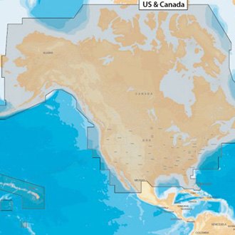
- Navionics® - Navionics+ US and Canada microSD Format Electronic Chart (MSD/NAV+NI)Navionics+ US and Canada microSD Format Electronic Chart by Navionics®. All-in-one max detailed cartography for marine and lakes makes Navionics+ the perfect choice for cruising, fishing and sailing. Get the most accurate navigational...Plotter Sync allows Raymarine, Lowrance, Simrad and B&G plotter owners to transfer routes and markers, update charts and more!Boat Safer. Fish Smarter. Change the way you view Navionics charts and focus on the details that matter most to you$179.00In Stock - Ships within 24 hrs
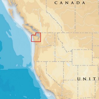
- Navionics® - Platinum+ Puget Sound microSD Format Electronic Chart (MSD/638P+)Platinum+ Puget Sound microSD Format Electronic Chart by Navionics®. Head out with confidence! All the same marine and lakes content and advanced features found in Navionics+ are augmented with 3D View, satellite overlay and panoramic...The most advanced technology and best imaging available in multi-dimensional chartsImproved 3D view with enchanced bottom contour profiles and high-resolution photo overlay$139.47In Stock - Ships within 24 hrs
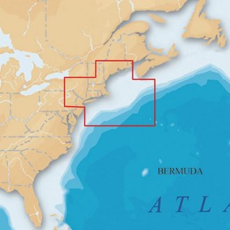
- Navionics® - Platinum+ US North-East and Canyons microSD Format Electronic Chart (MSD/904P+)Platinum+ US North-East and Canyons microSD Format Electronic Chart by Navionics®. Head out with confidence! All the same marine and lakes content and advanced features found in Navionics+ are augmented with 3D View, satellite overlay...The most advanced technology and best imaging available in multi-dimensional chartsImproved 3D view with enchanced bottom contour profiles and high-resolution photo overlay$148.22In Stock - Ships within 24 hrs
- Navionics® - Platinum+ Vancouver Island microSD Format Electronic Chart (MSD913PPLUS)Platinum+ Vancouver Island microSD Format Electronic Chart by Navionics®. Head out with confidence! All the same marine and lakes content and advanced features found in Navionics+ are augmented with 3D View, satellite overlay and...The most advanced technology and best imaging available in multi-dimensional chartsImproved 3D view with enchanced bottom contour profiles and high-resolution photo overlay$324.45In Stock - Ships in 24 to 48 hrs
- C-MAP® - 4D North Asia SD-Card Format Electronic Chart (M-AN-D050-MS)4D North Asia SD-Card Format Electronic Chart by C-MAP®. C-MAP 4D is the latest evolution of electronic charting technology, combining award-winning vector chart data with exclusive Dynamic Raster Charts and the ability to view charts...Full Featured Vector Charts: Provides a wealth of chart detail with the versatility to customize data layers and how they are viewedDynamic Raster: Traditional "paper chart" look with unique ability to access information on buoys, lights and other details$214.92In Stock - Ships within 24 hrs
- C-MAP® - Max-N+ South America & the Caribbean microSD Format Electronic Chart (M-SA-Y038-MS)Max-N+ South America & the Caribbean microSD Format Electronic Chart by C-MAP®. C-MAP MAX-N+ brings trusted C-MAP data and advanced charting features to users of compatible Lowrance, Simrad and B&G navigation systems. Whether you’re...Dynamic Raster Charts give sailors a traditional “nautical chart” view with the ability to access important information. High-Resolution Bathymetric (HRB) charts and Sportfishing Data deliver powerful technology for avid anglersTides & Currents projections help both sailors and anglers plan their day$134.89In Stock - Ships within 24 hrs
- C-MAP® - Reveal X Coastal Gulf of Mexico and the Bahamas microSD Format Bathymetric Electronic Chart (M-NA-T-204-R-MS)Reveal X Coastal Gulf of Mexico and the Bahamas microSD Format Bathymetric Electronic Chart by C-MAP®. A Fresh, Dynamic Navigation Experience. Always have the latest chart data at your fingertips with the C-MAP X range. With dynamic...Next-Generation Charts: Fresh new chart presentation, with full-featured vector data and rich featuresHigh-Res Bathymetry: The best C-MAP® bathy data, with all-new, intuitive Map Inspector tool$269.99In Stock - Ships within 24 hrs
- C-MAP® - Reveal X US South/East Lakes microSD Format Electronic Chart (M-NA-T-214-R-MS)Reveal X US South/East Lakes microSD Format Electronic Chart by C-MAP®. A Fresh, Dynamic Navigation Experience. Always have the latest chart data at your fingertips with the C-MAP X range. With dynamic presentation ensuring a clear,...Next-Generation Charts: Fresh new chart presentation, with full-featured vector data and rich featuresHigh-Res Bathymetry: The best C-MAP® bathy data, with all-new, intuitive Map Inspector tool$183.59In Stock - Ships within 24 hrs
- Navionics® - Navionics+ Chile, Argentina & Easter Island microSD Format Electronic Chart (010-C1365-30)Navionics+ Chile, Argentina & Easter Island microSD Format Electronic Chart by Navionics®. Coastal coverage of South America from Arica, Chile to Rio Grande, Brazil. Coverage includes Easter Island, Cape Horn, the Falkland Islands/Islas...Marine and lake chartsOne foot contours$142.22In Stock - Ships within 24 hrs
- Navionics® - Navionics+ Mexico, Caribbean to Brazil microSD Format Electronic Chart (010-C1364-30)Navionics+ Mexico, Caribbean to Brazil microSD Format Electronic Chart by Navionics®. Coastal coverage of Mexico, Central America and Brazil. Coverage includes the US Gulf Coast and the eastern US coast to Savannah, GA; Bermuda; the...Marine and lake chartsOne foot contours$142.22In Stock - Ships within 24 hrs
- Navionics® - Navionics+ US & Coastal Canada microSD Format Electronic Chart (010-C1366-30)Navionics+ US & Coastal Canada microSD Format Electronic Chart by Navionics®. Detailed coverage of the entire U.S. coasts, lakes, rivers and inland waterways, plus Alaska and Hawaii. Canada coverage of coastal British Columbia, the...Marine and lake chartsOne foot contours$209.96In Stock - Ships in 24 to 48 hrs
- Navionics® - Navionics+ US East microSD Format Electronic Chart (010-C1370-30)Navionics+ US East microSD Format Electronic Chart by Navionics®. Detailed coverage of the lakes, rivers and coasts of Connecticut, Delaware, Illinois, Indiana, Kentucky, Maine, Maryland, Massachusetts, Michigan, New Hampshire, New...Marine and lake chartsOne foot contours$157.47In Stock - Ships in 24 to 48 hrs
- Navionics® - Navionics+ US North microSD Format Electronic Chart (010-C1368-30)Navionics+ US North microSD Format Electronic Chart by Navionics®. Detailed coverage of the lakes and rivers of Iowa, Michigan, Minnesota, North Dakota, South Dakota, Wisconsin, and the U.S. waters of the Great Lakes that border those...Marine and lake chartsOne foot contours$157.47In Stock - Ships in 24 to 48 hrs
- Navionics® - Navionics+ US South microSD Format Electronic Chart (010-C1369-30)Navionics+ US South microSD Format Electronic Chart by Navionics®. Detailed coverage of the lakes, rivers and coasts of Alabama, Arkansas, Florida, Georgia, Kansas, Louisiana, Mississippi, Missouri, Nebraska, New Mexico, Oklahoma,...Marine and lake chartsOne foot contours$157.47In Stock - Ships in 24 to 48 hrs
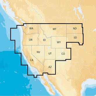
- Navionics® - Navionics+ US West microSD Format Electronic Chart (010-C1371-30)Navionics+ US West microSD Format Electronic Chart by Navionics®. Detailed coverage of the lakes, rivers and coasts of Arizona, California, Colorado, Idaho, Montana, Nevada, North Dakota, Oregon, South Dakota, Utah, Washington, and...Marine and lake chartsOne foot contours$157.47In Stock - Ships in 24 to 48 hrs
- Navionics® - Platinum+ Chile, Argentina & Easter Island microSD Format Electronic Chart (010-C1365-40)Platinum+ Chile, Argentina & Easter Island microSD Format Electronic Chart by Navionics®. Coastal coverage of South America from Arica, Chile to Rio Grande, Brazil. Coverage includes Easter Island, Cape Horn, the Falkland Islands/Islas...The most advanced technology and best imaging available in multi-dimensional chartsImproved 3D view with enchanced bottom contour profiles and high-resolution photo overlay$419.94In Stock - Ships in 24 to 48 hrs
- Navionics® - Platinum+ Maine microSD Format Electronic Chart (SD/673P+)Platinum+ Maine microSD Format Electronic Chart by Navionics®. Head out with confidence! All the same marine and lakes content and advanced features found in Navionics+ are augmented with 3D View, satellite overlay and panoramic photos...The most advanced technology and best imaging available in multi-dimensional chartsImproved 3D view with enchanced bottom contour profiles and high-resolution photo overlay$215.94In Stock - Ships in 24 to 48 hrs
- Navionics® - Platinum+ Mexico, Caribbean to Brazil microSD Format Electronic Chart (010-C1364-40)Platinum+ Mexico, Caribbean to Brazil microSD Format Electronic Chart by Navionics®. Coastal coverage of Mexico, Central America and Brazil. Coverage includes the US Gulf Coast and the eastern US coast to Savannah, GA; Bermuda; the...The most advanced technology and best imaging available in multi-dimensional chartsImproved 3D view with enchanced bottom contour profiles and high-resolution photo overlay$419.94In Stock - Ships in 24 to 48 hrs
- Navionics® - Platinum+ US East microSD Format Electronic Chart (010-C1370-40)Platinum+ US East microSD Format Electronic Chart by Navionics®. Detailed coverage of the lakes, rivers and coasts of Connecticut, Delaware, Illinois, Indiana, Kentucky, Maine, Maryland, Massachusetts, Michigan, New Hampshire, New...The most advanced technology and best imaging available in multi-dimensional chartsImproved 3D view with enchanced bottom contour profiles and high-resolution photo overlay$262.46In Stock - Ships in 24 to 48 hrs
- Navionics® - Platinum+ US North microSD Format Electronic Chart (010-C1368-40)Platinum+ US North microSD Format Electronic Chart by Navionics®. Detailed coverage of the lakes and rivers of Iowa, Michigan, Minnesota, North Dakota, South Dakota, Wisconsin, and the U.S. waters of the Great Lakes that border those...The most advanced technology and best imaging available in multi-dimensional chartsImproved 3D view with enchanced bottom contour profiles and high-resolution photo overlay$139.47In Stock - Ships within 24 hrs
- Navionics® - Platinum+ US South microSD Format Electronic Chart (010-C1369-40)Platinum+ US South microSD Format Electronic Chart by Navionics®. Detailed coverage of the lakes, rivers and coasts of Alabama, Arkansas, Florida, Georgia, Kansas, Louisiana, Mississippi, Missouri, Nebraska, New Mexico, Oklahoma,...The most advanced technology and best imaging available in multi-dimensional chartsImproved 3D view with enchanced bottom contour profiles and high-resolution photo overlay$139.47In Stock - Ships within 24 hrs
- Navionics® - Platinum+ US West microSD Format Electronic Chart (010-C1371-40)Platinum+ US West microSD Format Electronic Chart by Navionics®. Detailed coverage of the lakes, rivers and coasts of Arizona, California, Colorado, Idaho, Montana, Nevada, North Dakota, Oregon, South Dakota, Utah, Washington, and...The most advanced technology and best imaging available in multi-dimensional chartsImproved 3D view with enchanced bottom contour profiles and high-resolution photo overlay$262.46In Stock - Ships in 24 to 48 hrs

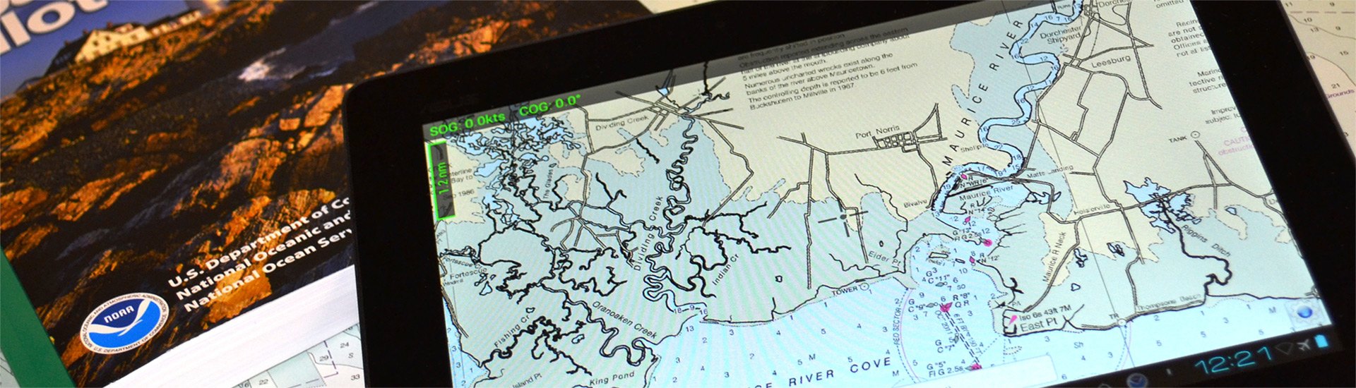
A safe boating experience cannot be imagined without nautical maps. Though conventional paper marine maps are still used on every boat, new technologically-advanced electronic charts have made the entire map reading and course planning routine much easier. So what is electronic cartography? The definition is pretty straightforward - electronic charts are digital versions of the most dependable government-issued paper charts and maps crated to simplify your navigation.
The data that is used by electronic charts comes from a number of government sources including NOAA, Canadian Hydrographics, and many others. Electronic charts give mariners greater possibilities on the water, providing you with innovative object-oriented cartography. Normally the electronic charts are displayed on chartplotters, multifunction displays (smartphones) or personal computers. Chartplotters, that are typically waterproof, are usually opted for when you own smaller 40’-50’ boats, while tablets and smartphones are well-suited for larger sail and power boats. PCs are usually used on large vessels and commercial boats.
Electronic charts are available in a number of formats: dynamic raster scanned charts (Maptech) that are basically direct video images of paper charts. They are precise and reliable versions of conventional paper charts. Vector charts (Garmin, Navionics, C-Map) typically take less memory as they have the information transformed into coordinates in a data file. Vector charts are “object oriented”, so when a cursor is positioned over icons, numerals, words or other features, additional windows with detailed descriptions will pop up. New generation 3D maps with high-definition relief will provide you with improved underwater view.
Electronic charts for chartplotters are usually available on small microSD memory cards that can be inserted into a GPS unit. In their turn, smartphone and PC charts are downloadable. While the paper maps show signs of heavy use, over time signaling you to get a newer version, the electronic chart will look brand new, but may pose danger when outdated. Thus, your electronic maps should be regularly updated and kept current to provide greater level of protection against marine hazards. Either used for recreational and commercial boating or fishing, interactive electronic charts will help you make the most of your boating experience.